The Exodus is probably the most famous journey in human history. The story of the Israelites’ liberation from Egyptian slavery, the crossing of the Red Sea, the forty years in the wilderness, and the entry into the Promised Land has shaped not only Judaism and Christianity but the very idea of freedom in Western civilization. Yet when we read this story, we rarely think about the actual geography on which it unfolded. Where exactly did the Israelites depart from? What route did they follow? What does the desert they wandered for forty years actually look like? And what can you see today if you trace this route?
I have walked much of this road — from the pyramids at Giza through the Sinai desert to Jordan — and I can say that the geography of the Exodus is not merely a backdrop for a theological story. It is an integral part of the story itself. The desert is not a metaphor. It is real, overwhelming and, in its harsh way, magnificent. When you understand the terrain, you understand the text differently.
Egypt: The Starting Point
Everything begins in Egypt, at that time the most advanced civilization on earth. The Israelites were not leaving just any place. They were leaving a world of pyramids, colossal temples, and the Nile that made the desert bloom. The biblical text captures this tension repeatedly — even after liberation, the people looked back with nostalgia:
“We remember the fish we ate in Egypt at no cost — also the cucumbers, melons, leeks, onions and garlic.”
— Numbers 11:5
This nostalgia was not irrational. Ancient Egypt offered material security that the desert simply could not match. The Nile Delta, with its extraordinarily fertile soil, fed a population of millions. Egypt’s granary was legendary — even the Romans, a millennium and a half later, depended on Egyptian grain.
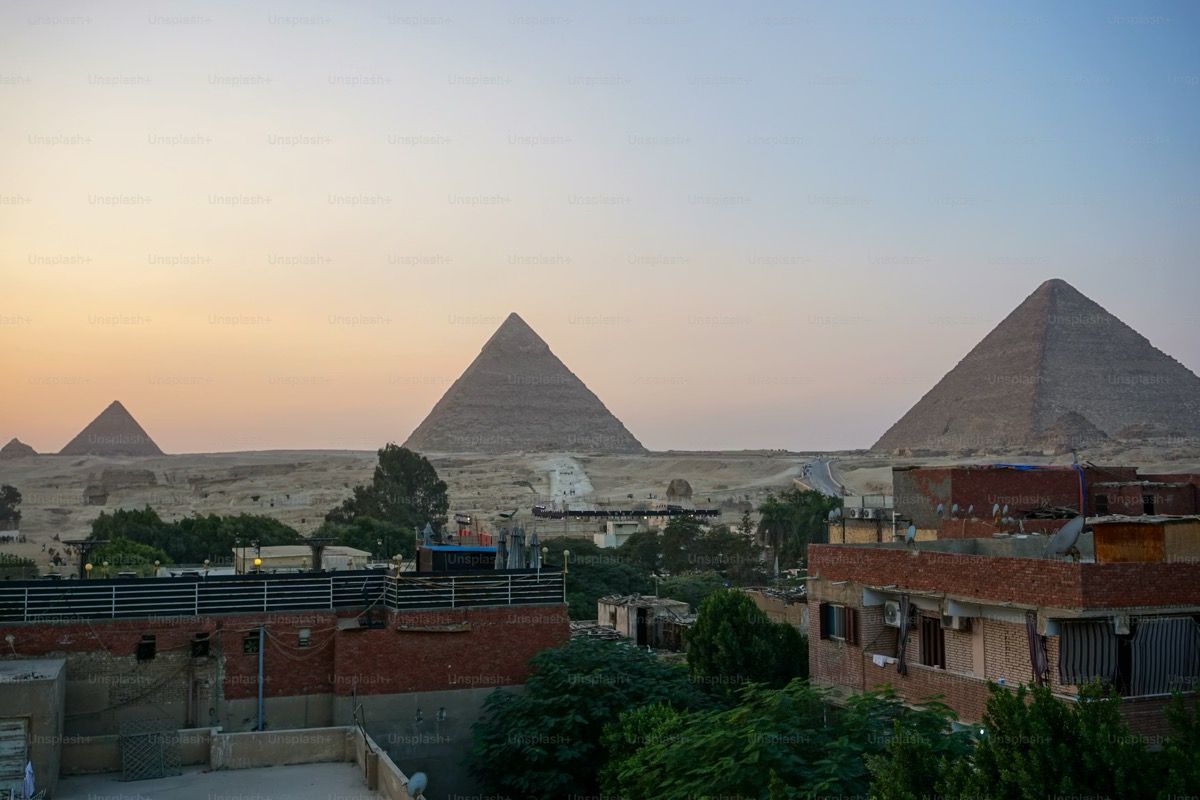
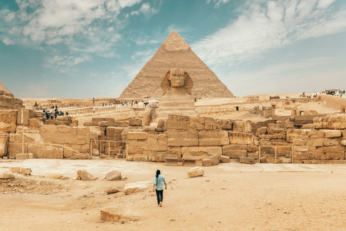
Today, when you visit Egypt, the contrast is still visible. You stand beside the pyramids — structures of a precision and grandeur that take your breath away — and you understand what it meant to leave all this for the unknown. The Pyramids of Giza, the Sphinx, the temples of Luxor and Karnak — all of these already existed when the Israelites lived in Egypt, though in different forms from what we see today. The monumentality of Egypt was designed to communicate a simple message: here is order, here is power, here is the eternal. And God asked the Israelites to leave this very “eternal” for a road through the wilderness.
The exact point of departure is still debated. The biblical text mentions Rameses (or Pi-Ramesses) as the gathering point and Succoth as the first stop. Pi-Ramesses, identified with the site at Qantir in the eastern Nile Delta, was one of the capitals of Ramesses II — the pharaoh whom many consider the pharaoh of the Exodus, though this identification remains contested in academic circles. From Qantir to the edge of the Sinai desert is approximately one hundred fifty kilometers — a distance that a multitude of people with children, elderly, and animals would have covered in several days.
The Crossing of the Red Sea: Where and How
One of the most debated subjects in Exodus geography is the location of the Red Sea crossing. The Hebrew term “Yam Suph” translates literally as “Sea of Reeds” and does not necessarily refer to what we call the Red Sea today. Several hypotheses exist:
The northern hypothesis places the crossing in the area of the Bitter Lakes or Lake Timsah, along the route of the modern Suez Canal. This area was in antiquity a system of lakes and marshes separating Egypt from the Sinai Peninsula. The southern hypothesis favors the Gulf of Suez, the northern extremity of the Red Sea proper. The Gulf of Aqaba hypothesis, more recent and more controversial, places the crossing much farther southeast.
Regardless of the exact location, what matters theologically is the clarity of the message: God opens a road where no road exists. The water parts, the bottom becomes dry, the people cross. It is an act of creation in miniature — just as in the beginning God separated the waters from the dry land (Genesis 1:9), so He separates the waters to create a road of liberation.
“Then Moses stretched out his hand over the sea, and all that night the Lord drove the sea back with a strong east wind and turned it into dry land. The waters were divided.”
— Exodus 14:21
The Sinai Peninsula: The Desert as School
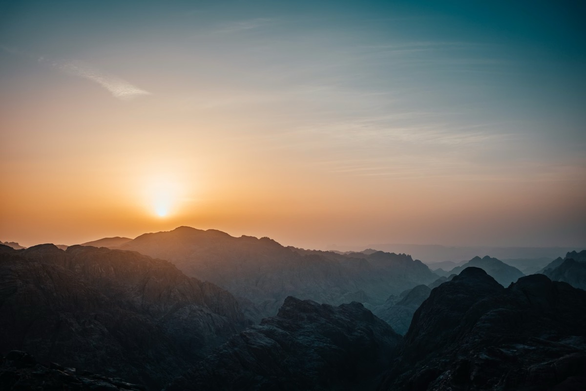
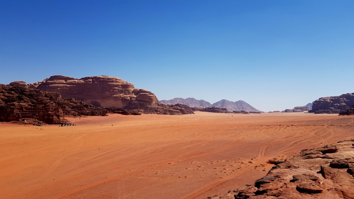
After crossing the sea, the Israelites enter the Sinai Peninsula — a triangle of desert roughly 60,000 square kilometers in area, bounded by the Gulf of Suez to the west, the Gulf of Aqaba to the east, and the Mediterranean to the north. It is a landscape of severe beauty: limestone plateaus to the north, sandy desert in the center, and granite mountains to the south, with peaks exceeding 2,600 meters.
The Sinai desert is not a dead wasteland. It is an extreme environment, but a living one. Bedouins have inhabited it for millennia, knowing every spring, every valley where goats graze and palm trees grow. But for a population coming from the fertile Nile Delta, the shock was immense. Neither water nor food was guaranteed. Every day was an act of dependence on God — or, seen from the Israelites’ perspective, a constant source of anxiety and revolt.
The first stops mentioned in the Bible reflect this tension. At Marah, the water was bitter and undrinkable — until Moses, at God’s command, threw a piece of wood into the water and it became sweet (Exodus 15:23-25). At Elim, they found twelve springs and seventy palm trees — a real oasis in a real desert (Exodus 15:27). In the Wilderness of Sin, they received manna — the heavenly bread that became the symbol of divine providence.
“Human beings ate the bread of angels; he sent them all the food they could eat.”
— Psalm 78:25
These stops are not literary inventions. In the Sinai Peninsula there are real oases — Ain Musa (the Spring of Moses), Wadi Feiran, the oasis at Ain Hudra — that correspond to the biblical descriptions. When you travel through Sinai and see a thread of green water appearing in a dry valley, you physically understand what a spring meant for a people walking through the wilderness.
Mount Sinai: The Encounter with God
The climactic point of the journey through Sinai is not an arrival but an encounter. Approximately three months after leaving Egypt, the Israelites reach Mount Sinai, where Moses receives the Law — the Ten Commandments and the entire legislative code that will define the identity of the people of Israel.
The traditional location of Mount Sinai is Jebel Musa (the Mountain of Moses), a red granite peak of 2,285 meters in the southern peninsula. At its foot stands Saint Catherine’s Monastery, built in the sixth century by order of Emperor Justinian and still functioning — the oldest continuously operating Christian monastery in the world. It houses an extraordinary collection of manuscripts and icons, including some of the oldest copies of the Septuagint.
The ascent of Jebel Musa is usually made at night, in order to arrive at the summit at sunrise. There are approximately 3,750 steps carved into the rock by the monastery’s monks — a journey of two to three hours. When you reach the top and watch the sunrise above a landscape of granite mountains stretching in every direction, you understand why tradition chose this place. It is a landscape that makes you silent. It is a landscape of revelation.
Other hypotheses for the location of Mount Sinai exist — Jebel al-Lawz in Saudi Arabia, Har Karkom in the Negev — but none has convincingly replaced the tradition. And, honestly, the exact location matters less than what happened there. At Sinai, a people of freed slaves received an identity. They were no longer defined by their slavery, but by the Law they received. This transformation — from slaves to a covenant people — is the heart of the Exodus.
“You yourselves have seen what I did to Egypt, and how I carried you on eagles’ wings and brought you to myself. Now if you obey me fully and keep my covenant, then out of all nations you will be my treasured possession.”
— Exodus 19:4-5
The Forty Years: Wandering as Divine Pedagogy
After the Sinai episode, the Israelites head north toward Kadesh Barnea, on the southern edge of Canaan. From here they send twelve spies into the Promised Land. Ten return with a discouraging report — the people are giants, the cities are fortified, we have no chance. Only Caleb and Joshua say otherwise. The people choose to listen to the majority and refuse to enter. The punishment is famous: forty years of wandering in the desert, one year for each day the spies spent in Canaan.
“Your children will be shepherds here for forty years, suffering for your unfaithfulness, until the last of your bodies lies in the wilderness.”
— Numbers 14:33
These forty years are the least documented segment of the Exodus. Numbers 33 provides a list of stops — over forty stations — but many of them cannot be identified with certainty on the map. What we know is that the Israelites remained for an extended period at Kadesh Barnea (probably identified with Ain el-Qudeirat, an oasis with strong springs in northern Sinai) and that they migrated through areas corresponding to the present-day southern Negev and the northwest of the Sinai Peninsula.
Theologically, these forty years served a precise purpose. The generation that had known slavery and still thought like a slave people had to die in the desert. The next generation, born in freedom and raised under the Law, was the one prepared to enter the inheritance. The desert was not pure punishment — it was pedagogy. A harsh school, but a necessary one.
The Road Through Transjordan: The Final Stages
In the last year of the journey, the Israelites head east and north, bypassing Edom and Moab — two kingdoms that refused them passage through their territory. The route takes them through what is today southern and eastern Jordan, an area of dramatic beauty.
Several crucial events occur here. On Mount Hor (possibly Jebel Harun, near Petra), Aaron dies and is buried. The Israelites fight and defeat the Amorite kings Sihon and Og, gaining territory east of the Jordan. And on the plains of Moab, with a view toward Jericho and the Promised Land, Moses delivers his final addresses — the book of Deuteronomy — and dies on Mount Nebo.
Mount Nebo, approximately thirty kilometers southwest of Amman, is one of the most emotionally powerful places on the entire Exodus route. From its summit you see exactly what Moses saw: the Jordan Valley, the Dead Sea gleaming in the sunlight, the hills of Judea, and on clear days, even Jerusalem. Moses saw everything, but he did not enter. After forty years of leadership, after all the struggles, after all the people’s rebellions, after all the prayers — he died at the border.
“Then the Lord showed him the whole land — from Gilead to Dan, all of Naphtali, the territory of Ephraim and Manasseh, all the land of Judah as far as the Mediterranean Sea, the Negev and the whole region from the Valley of Jericho, the City of Palms, as far as Zoar.”
— Deuteronomy 34:1-3
I have stood on Mount Nebo and gazed at exactly the same panorama. It is a moment that strikes you in the chest. Moses did not fail. He fulfilled everything that was asked of him. But the entry into Canaan belonged to another generation, another leader. It is a lesson about faithfulness without immediate reward — about the fact that sometimes you do your part and leave the rest in God’s hands.
Petra and the Passage Through Edom
Although the Israelites did not pass through Edom — the Edomites refused them access — the area is essential for understanding the geography of the Exodus. Edom corresponds roughly to southern Jordan today, and its later capital, Petra, is one of the most spectacular archaeological sites in the world.
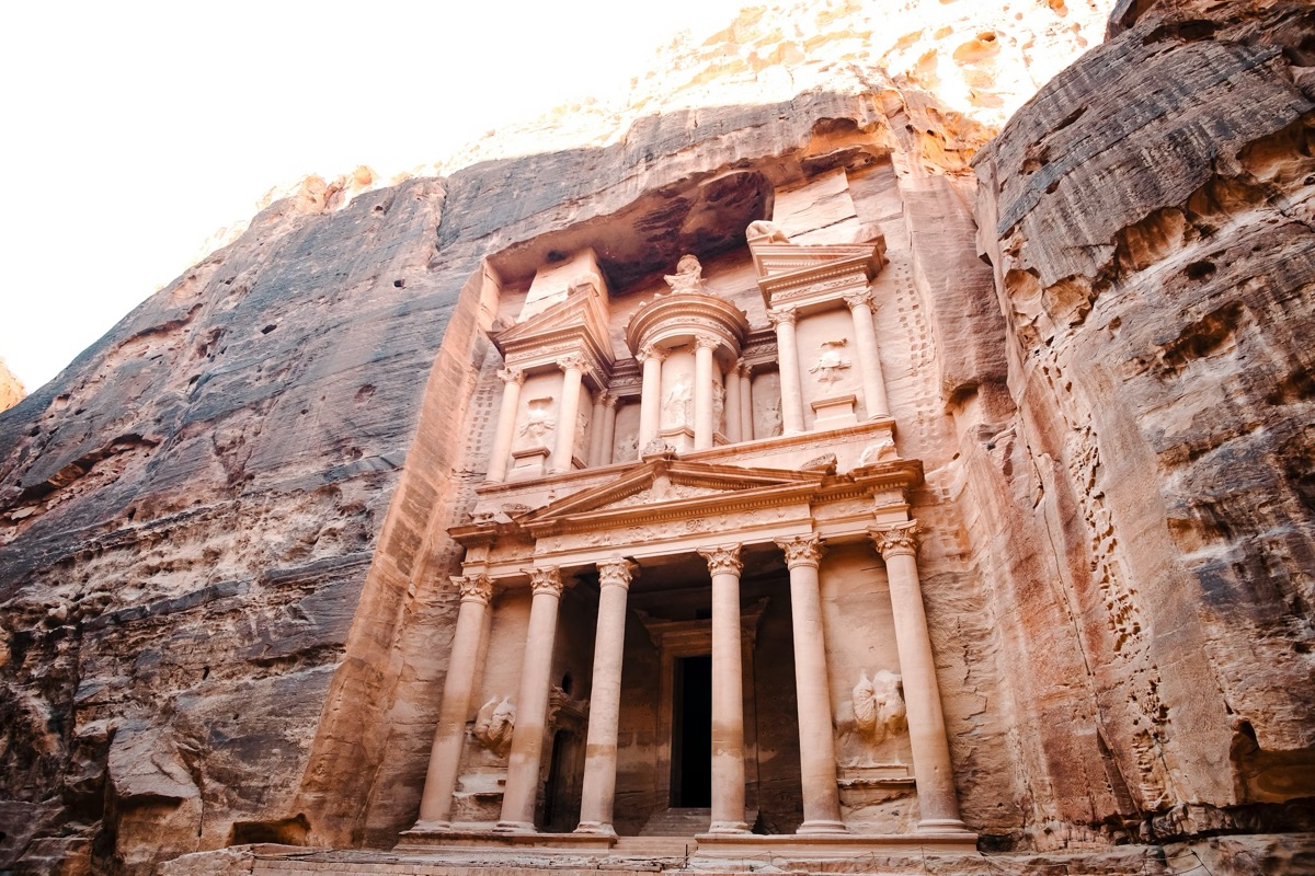
Petra did not exist in its monumental form during the Exodus — it was built by the Nabataeans beginning in the fourth century BC. But the area around Petra was inhabited by the Edomites, and the biblical text places important events here. Mount Seir, the homeland of the Edomites, is mentioned frequently in the Old Testament. Jebel Harun (the Mountain of Aaron), which dominates Petra, is the traditional site of Aaron’s death.
Today, Petra is an essential stop on the Exodus route. The walk through the Siq — the narrow canyon leading to the Treasury — is an experience that prepares you for the sacred dimension of the entire journey. The sandstone walls rise seventy meters above you, light filters through a sliver of sky, and when you emerge from the Siq and see the Treasury facade, you understand why the Nabataeans chose this place. It is a place that inspires awe.
What You Can See Today on the Exodus Route
The Exodus route can be traveled today on a journey combining Egypt, the Sinai Peninsula, and Jordan. Here are the principal stops:
In Egypt: the Pyramids of Giza and the Sphinx, the Egyptian Museum in Cairo (with royal mummies and artifacts from the New Kingdom period), the Delta area where Pi-Ramesses was located (accessible, but without spectacular ruins).
In Sinai: Saint Catherine’s Monastery and the ascent of Jebel Musa, the Ain Musa oasis, Wadi Feiran. The Sinai Peninsula requires careful planning and, depending on the area, a security escort.
In Jordan: Mount Nebo with its extraordinary panorama, Madaba with the famous sixth-century mosaic map of the Holy Land, Petra, Wadi Rum (the red sandstone desert where numerous film productions have been shot), and Bethany Beyond the Jordan — the traditional site of Jesus’s baptism, at the edge of the Jordan River.
Geography as Theology
What makes the Exodus route so powerful is not just the beauty of the landscapes, but the fact that the geography itself becomes a carrier of theological meaning. Egypt represents slavery and the false security of the old world. The desert represents purification, testing, and formation. The Jordan represents the threshold — the boundary between promise and fulfillment. And Canaan, the land flowing with milk and honey, represents God’s rest — not a paradise, but a place where faith and obedience are rewarded.
“Remember how the Lord your God led you all the way in the wilderness these forty years, to humble and test you in order to know what was in your heart.”
— Deuteronomy 8:2
This verse summarizes the entire meaning of the journey: it was not a pointless detour but an intentional formation. Every stop, every water crisis, every moment of hunger or revolt was a chapter in the education of a people. The desert taught them that bread does not come from themselves but from God. That water can spring from rock. That the cloud and fire guiding them are not natural phenomena but the divine presence itself.
When you travel this route today, by car or bus rather than on foot, with bottled water rather than manna, you realize how much modern comfort separates us from the experience of those people. But you also realize how relevant the message remains. Every person passes, at some point, through their own desert. Every person knows the moment when they want to return to Egypt, to the old and familiar safety. And every person needs, at some point, to arrive at their own Mount Nebo and look forward, even if entering the promise still requires one more step of faith.
The Exodus is not merely the history of an ancient people. It is the map of each one of our journeys.